![](/images/other/stat-length.png)
![Randonnée Marche Sorges et Ligueux en Périgord - Ligueux Brame et Abbatiale 11km - Photo](https://media.geolcdn.com/t/1900/400/ext.pjpeg?maxdim=2&url=https%3A%2F%2Fstatic1.geolcdn.com%2Fsiteimages%2Fupload%2Ffiles%2F1553511878bg_sport_marche.png)
Ligueux Brame et Abbatiale 11km
YV24
Utilisateur
![Longueur](/images/other/stat-length.png)
Longueur
10,5 km
![Altitude max](https://static1.geolcdn.com/siteimages/upload/files/1508320355ic_sort_altitude_max_24dp.png)
Altitude max
214 m
![Dénivelé positif](https://static1.geolcdn.com/siteimages/upload/files/1508320355ic_sort_den_pos_24dp.png)
Dénivelé positif
216 m
![Km-Effort](/images/other/stat-length.png)
Km-Effort
13,4 km
![Altitude min](https://static1.geolcdn.com/siteimages/upload/files/1508320355ic_sort_altitude_min_24dp.png)
Altitude min
149 m
![Dénivelé négatif](https://static1.geolcdn.com/siteimages/upload/files/1508320355ic_sort_den_neg_24dp.png)
Dénivelé négatif
218 m
![Boucle](https://static1.geolcdn.com/siteimages/upload/files/16400158638029165_repeat_loop_refresh_sync_direction_icon.png)
Boucle
Oui
Date de création :
2018-04-17 13:25:24.734
Dernière modification :
2018-04-17 13:25:24.734
![Marche](https://static1.geolcdn.com/sitytour/trail-icons/101.png)
2h54
Difficulté : Facile
![Scannez ce code QR pour ouvrir la randonnée dans l'application SityTrail](https://capi.geolives.com/qq0zvz2zws4bq2lad0pu/sitytour/trails/867306/qr.png?size=200)
Application GPS de randonnée GRATUITE
À propos
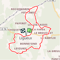
Randonnée Marche de 10,5 km à découvrir à Nouvelle-Aquitaine, Dordogne, Sorges et Ligueux en Périgord. Cette randonnée est proposée par YV24.
Description
Combinaison des boucles PDIPR du Brame et de l'Abbatiale. Tracé varié, un peu valloné, praticable en tout temps.
Localisation
Pays :
France
Région :
Nouvelle-Aquitaine
Département/Province :
Dordogne
Commune :
Sorges et Ligueux en Périgord
Localité :
Ligueux
Départ:(Dec)
Départ:(UTM)
329070 ; 5019616 (31T) N.
Commentaires
Randonnées à proximité
![Randonnée sport Sorges et Ligueux en Périgord - 2020-09-03_17h34m25_20-10-20 Ligueux - Photo](https://media.geolcdn.com/t/375/260/ext.jpg?maxdim=2&url=https%3A%2F%2Fsecurestorage.geolives.com%2Fsitytour%2Ftrail-bg%2Fdefault.jpg)
2020-09-03_17h34m25_20-10-20 Ligueux
sport
Très facile
(1)
Sorges et Ligueux en Périgord,
Nouvelle-Aquitaine,
Dordogne,
France
![](/images/other/stat-length.png)
10,5 km | 13,4 km-effort
Inconnu
![](https://static1.geolcdn.com/siteimages/upload/files/16400158638029165_repeat_loop_refresh_sync_direction_icon.png)
Oui
![Randonnée Marche Sorges et Ligueux en Périgord - Sorges Causses et sous bois 10 km - Photo](https://media.geolcdn.com/t/375/260/ext.jpg?maxdim=2&url=https%3A%2F%2Fstatic1.geolcdn.com%2Fsiteimages%2Fupload%2Ffiles%2F1553511878bg_sport_marche.png)
![Marche Marche](https://static1.geolcdn.com/sitytour/trail-icons/101.png)
Sorges Causses et sous bois 10 km
Marche
Facile
(1)
Sorges et Ligueux en Périgord,
Nouvelle-Aquitaine,
Dordogne,
France
![](/images/other/stat-length.png)
9,9 km | 12,6 km-effort
1h 49min
![](https://static1.geolcdn.com/siteimages/upload/files/16400158638029165_repeat_loop_refresh_sync_direction_icon.png)
Oui
![Randonnée Marche Sorges et Ligueux en Périgord - Sorges Téléthon 2013 11km - Photo](https://media.geolcdn.com/t/375/260/ext.jpg?maxdim=2&url=https%3A%2F%2Fstatic1.geolcdn.com%2Fsiteimages%2Fupload%2Ffiles%2F1553511878bg_sport_marche.png)
![Marche Marche](https://static1.geolcdn.com/sitytour/trail-icons/101.png)
Sorges Téléthon 2013 11km
Marche
Facile
(1)
Sorges et Ligueux en Périgord,
Nouvelle-Aquitaine,
Dordogne,
France
![](/images/other/stat-length.png)
11 km | 13,2 km-effort
2h 57min
![](https://static1.geolcdn.com/siteimages/upload/files/16400158638029165_repeat_loop_refresh_sync_direction_icon.png)
Oui
![Randonnée Marche Sorges et Ligueux en Périgord - Marche du dimanche 15 janvier à Ligueux - Photo](https://media.geolcdn.com/t/375/260/ca66f548-4426-4827-980d-dc4041496b72.jpg&format=jpg&maxdim=2)
![Marche Marche](https://static1.geolcdn.com/sitytour/trail-icons/101.png)
Marche du dimanche 15 janvier à Ligueux
Marche
Facile
Sorges et Ligueux en Périgord,
Nouvelle-Aquitaine,
Dordogne,
France
![](/images/other/stat-length.png)
6,8 km | 8,6 km-effort
1h 39min
![](https://static1.geolcdn.com/siteimages/upload/files/16400158638029165_repeat_loop_refresh_sync_direction_icon.png)
Non
![Randonnée Marche Sorges et Ligueux en Périgord - Boucle de l'Abbatiale - Photo](https://media.geolcdn.com/t/375/260/9612e021-d9e0-4a16-be1e-ceb9f3a734d7.jpg&format=jpg&maxdim=2)
![Marche Marche](https://static1.geolcdn.com/sitytour/trail-icons/101.png)
Boucle de l'Abbatiale
Marche
Facile
Sorges et Ligueux en Périgord,
Nouvelle-Aquitaine,
Dordogne,
France
![](/images/other/stat-length.png)
7,3 km | 8,9 km-effort
2h 1min
![](https://static1.geolcdn.com/siteimages/upload/files/16400158638029165_repeat_loop_refresh_sync_direction_icon.png)
Oui
![Randonnée Marche Sorges et Ligueux en Périgord - De Sorges à Perigueux sur la voie de Compostelle - Photo](https://media.geolcdn.com/t/375/260/4aaf4236-90c5-474d-8de9-7f6175f80c96.jpeg&format=jpg&maxdim=2)
![Marche Marche](https://static1.geolcdn.com/sitytour/trail-icons/101.png)
De Sorges à Perigueux sur la voie de Compostelle
Marche
Très difficile
Sorges et Ligueux en Périgord,
Nouvelle-Aquitaine,
Dordogne,
France
![](/images/other/stat-length.png)
25 km | 31 km-effort
5h 26min
![](https://static1.geolcdn.com/siteimages/upload/files/16400158638029165_repeat_loop_refresh_sync_direction_icon.png)
Non
![Randonnée Marche Sorges et Ligueux en Périgord - Boucle des châteaux - Photo](https://media.geolcdn.com/t/375/260/ba5fb264-42c9-43e2-90fa-f6bdc036a39c.jpg&format=jpg&maxdim=2)
![Marche Marche](https://static1.geolcdn.com/sitytour/trail-icons/101.png)
Boucle des châteaux
Marche
Difficile
Sorges et Ligueux en Périgord,
Nouvelle-Aquitaine,
Dordogne,
France
![](/images/other/stat-length.png)
14,4 km | 17,2 km-effort
3h 54min
![](https://static1.geolcdn.com/siteimages/upload/files/16400158638029165_repeat_loop_refresh_sync_direction_icon.png)
Oui
![Randonnée Marche Sorges et Ligueux en Périgord - Sorges bois et causse 11km - Photo](https://media.geolcdn.com/t/375/260/ext.jpg?maxdim=2&url=https%3A%2F%2Fstatic1.geolcdn.com%2Fsiteimages%2Fupload%2Ffiles%2F1553511878bg_sport_marche.png)
![Marche Marche](https://static1.geolcdn.com/sitytour/trail-icons/101.png)
Sorges bois et causse 11km
Marche
Difficile
Sorges et Ligueux en Périgord,
Nouvelle-Aquitaine,
Dordogne,
France
![](/images/other/stat-length.png)
10,9 km | 13,9 km-effort
3h 9min
![](https://static1.geolcdn.com/siteimages/upload/files/16400158638029165_repeat_loop_refresh_sync_direction_icon.png)
Oui
![Randonnée Marche Sorges et Ligueux en Périgord - Ligueux Saint Simeon MILPAS - Photo](https://media.geolcdn.com/t/375/260/ext.jpg?maxdim=2&url=https%3A%2F%2Fstatic1.geolcdn.com%2Fsiteimages%2Fupload%2Ffiles%2F1553511878bg_sport_marche.png)
![Marche Marche](https://static1.geolcdn.com/sitytour/trail-icons/101.png)
Ligueux Saint Simeon MILPAS
Marche
Difficile
Sorges et Ligueux en Périgord,
Nouvelle-Aquitaine,
Dordogne,
France
![](/images/other/stat-length.png)
11,2 km | 13,9 km-effort
2h 59min
![](https://static1.geolcdn.com/siteimages/upload/files/16400158638029165_repeat_loop_refresh_sync_direction_icon.png)
Oui
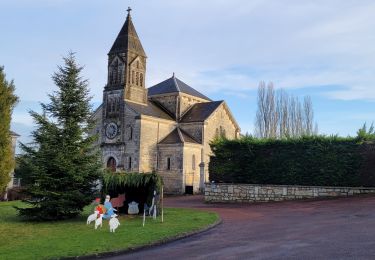
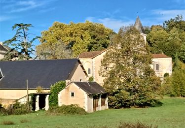
belle boucle en campagne avec de belles demeures.
très belle randonnée